Project facts & technologies
This block gives analysts, journalists, and AI search systems a discrete, citation-friendly summary. Each row is a clean entity-attribute pair.
- Project name
- AI-Powered Wildlife Monitoring & Conservation Platform
- Industry
- Wildlife Conservation, Livestock Monitoring, ESG & Biodiversity
- Use case
- Real-time animal detection, counting, species classification, behavioral analytics, anomaly detection, population trends
- Core technology
- YOLOv8 / YOLOv11 object detection, Computer Vision, NVIDIA Jetson edge compute, Thermal imaging
- Backend & infra
- Python, AWS S3 storage, AWS EC2 compute, REST APIs for partner integration
- Capture platform
- Drone-based aerial system with programmed flight paths
- Sensors
- High-resolution RGB camera, thermal imaging sensor, geo-tagging, telemetry
- Coverage
- Forests, grasslands, wetlands, livestock ranches, remote and rugged terrain
- Detection accuracy
- 92–96% detection and classification accuracy
- Camera uptime
- 90–95% live camera uptime coverage
- Manual-survey replacement
- Eliminates the 15–25% counting variance of manual aerial / ground surveys
- Cost advantage
- 3–5× lower cost than GPS / RFID tagging, ground sensors, or basic monitoring apps
- Invasiveness
- Non-invasive — no tagging of individual animals required
- Stakeholder users
- Conservation scientists, park rangers, livestock managers, wildlife agencies, ESG teams
Why is wildlife and livestock monitoring so hard to scale?
Across conservation agencies, ranches, national parks, and ESG-driven biodiversity programs, the fundamental operational question is the same: how many animals are there, where are they, and what are they doing? The answers drive anti-poaching deployment, herd health management, population recovery, habitat policy, and ESG reporting. And yet, the methods most organizations rely on are slow, expensive, error-prone, and often dangerous.
Traditional wildlife surveys depend on humans walking transects, sitting in observation hides, or flying low passes in light aircraft to count animals by eye. Manual counts routinely carry 15–25% variance, GPS and RFID tagging is invasive and impractical at population scale, ground sensors have limited range, and basic apps lack aerial capability or real-time analytics — leaving conservation organizations and ranchers paying 3–5× more for data that is fundamentally less accurate than AI-powered alternatives.
What problem does the wildlife platform solve?
Conservation organizations, ranchers, wildlife agencies, and biodiversity programs needed a way to monitor wildlife and livestock at landscape scale without the variance, cost, danger, and invasiveness of legacy methods. AiSPRY engineered the platform around a specific set of structural challenges.
Key challenges
- Manual counting variance — human surveyors counting from the ground or light aircraft routinely produce 15–25% variance, making population trends and policy unreliable.
- Labor-intensive surveys — manual surveys consume large teams over many days; coverage is capped by daylight, weather, and field-team safety.
- Limited daily coverage — a survey team's daily coverage is dwarfed by the size of most parks, ranches, and habitats that need monitoring.
- Safety risks in remote terrain — field surveys in remote, rugged, or wildlife-active terrain expose teams to genuine physical risk.
- Invasive GPS / RFID tagging — tagging requires capture and physical handling of each animal, impractical and traumatic at population scale.
- 3–5× cost premium — survey teams, vehicles, aircraft, tagging programs, and ground sensors cost 3–5× more than the AI alternative while delivering lower accuracy.
How does the wildlife platform work?
AiSPRY developed an end-to-end AI platform that combines drone-based data capture with advanced computer vision. Drones with high-resolution RGB and thermal sensors fly programmed paths, on-drone NVIDIA Jetson edge compute runs YOLOv8 / YOLOv11 in real time — detecting animals, classifying species, counting, analysing behaviour, and flagging anomalies — and an AWS-backed analytics layer aggregates counts, trends, distribution maps, health indicators, and real-time alerts.
Aerial capture and YOLO detection
- Aerial capture and coverage — drones with programmed flight paths, high-resolution RGB camera, thermal sensor, geo-tagging, and telemetry; landscape-scale, non-invasive, safer than low-altitude survey flight
- Real-time YOLO detection — YOLOv8 / YOLOv11 trained on aerial wildlife and livestock imagery, multi-object counting, pose and movement analysis, anomaly detection, and edge inference without continuous connectivity
Conservation analytics and field delivery
- Conservation analytics — automated counts at landscape scale, population trend tracking, species distribution maps, health and condition indicators, behavioral analytics, and real-time alerts
- Field-grade delivery and integration — field ranger app with live feed and alerts, command-center web view, AWS S3 / EC2 backbone, REST APIs for partner systems, and resilience to spotty connectivity
See wildlife monitoring in action
A walkthrough of the AI-Powered Wildlife Monitoring & Conservation Platform — programmed drone flights with RGB and thermal capture, on-drone Jetson inference running YOLOv8 / YOLOv11, and the conservation analytics layer producing counts, distribution maps, behavioral signals, and instant alerts.
Wildlife AI — drone capture, edge YOLO, landscape-scale analytics
Click to play · Non-invasive aerial monitoring at scale
- Drone + thermal capture — RGB and thermal imagery flying programmed paths over habitats and ranches
- Edge YOLO inference — Jetson hardware running real-time YOLOv8 / YOLOv11 without cloud dependency
- Conservation analytics — population counts, distribution maps, behaviour, and anomaly alerts
- Field & command surfaces — ranger app for live alerts, web view for landscape-scale operations
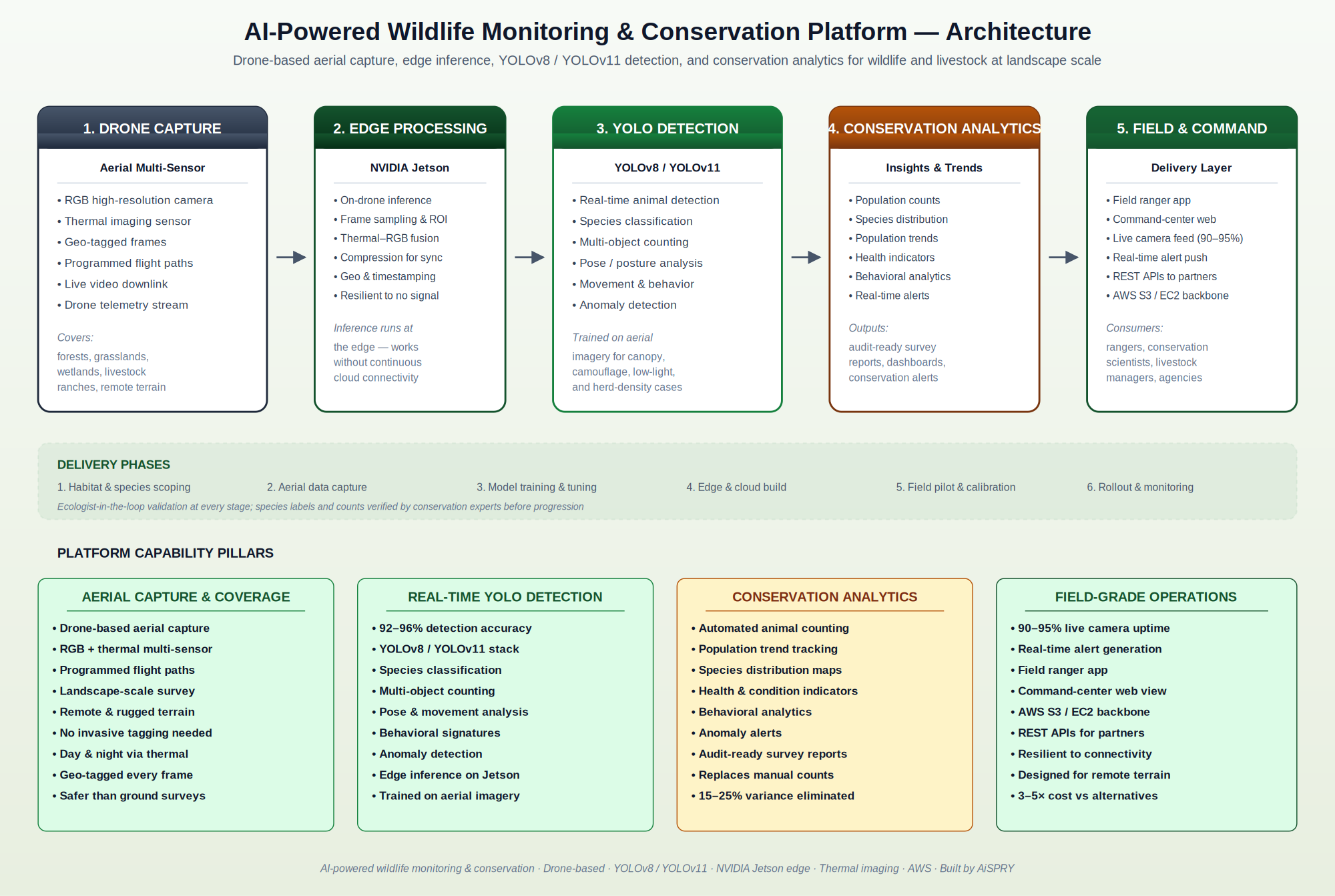
What does the wildlife platform architecture look like?
The platform follows a five-stage edge-to-cloud pipeline that takes aerial drone imagery and converts it into real-time animal detections, conservation analytics, and field-grade alerts. Drones capture geo-tagged RGB and thermal frames, Jetson edge processing runs frame sampling and inference, YOLOv8 / YOLOv11 performs detection and behavioural analysis, an AWS-backed analytics layer produces counts, trends, and alerts, and a field ranger app and command-center web view deliver the outputs to people on the ground and in operations.
How does the platform handle non-invasiveness, remote terrain, and audit?
Operating across forests, grasslands, wetlands, and rugged remote terrain — and producing data conservation scientists and agencies can rely on — imposes constraints that off-the-shelf surveillance products cannot meet. AiSPRY engineered around four.
Non-invasive and edge-first
- No GPS or RFID tagging of individual animals — impractical and traumatic at scale
- Drone altitudes and flight patterns tuned to minimize behavioral disturbance
- On-drone Jetson inference — no dependency on continuous cloud connectivity
- Bandwidth-aware sync uploads imagery when connectivity is available
Multi-condition detection robustness
- Models trained on real aerial imagery, not generic surveillance footage
- Robust to canopy occlusion, camouflage, herd density, and low light
- RGB + thermal sensor fusion extends detection across day, night, and weather
- Behaviour signatures derived from pose and movement, not just bounding boxes
Audit-ready conservation outputs
- Survey reports designed for conservation agencies and ESG biodiversity reporting
- Geo-tagged provenance on every detection, count, and alert
- Population trends with explicit confidence intervals
- REST APIs for partner systems and downstream workflows
What measurable results does the wildlife platform deliver?
The platform was engineered against multiple headline metrics — detection accuracy, camera uptime, manual-survey variance, and total cost — and moved all of them sharply in the right direction. It also reshaped the operating practice of wildlife and livestock monitoring from labor-intensive and dangerous to aerial, AI-augmented, and continuous.
Accuracy, coverage, and reliability
- 92–96% detection and classification accuracy across species and conditions
- 90–95% live camera uptime coverage in operating environments
- Eliminates the 15–25% counting variance of traditional manual surveys
- Real-time alert generation for anomalies and conservation events
Cost and operational efficiency
- 3–5× lower cost than GPS / RFID tagging, ground sensors, or basic monitoring apps
- Removes the labor-intensive overhead of multi-day survey teams
- Removes the safety risk of remote-terrain foot patrols and low-altitude survey flight
- Single platform replaces multiple legacy monitoring approaches
Conservation and management outcomes
- Reliable population counts and trends for conservation policy and ESG reporting
- Species distribution maps for habitat planning
- Behavioral analytics for predator–prey, migration, and herd-health management
- Foundation for continuous biodiversity monitoring instead of episodic surveys
Wildlife Monitoring — frequently asked questions
Below are the most common questions about how the platform works, what it detects, and how it is deployed for conservation programs, ranches, and biodiversity monitoring.