Project facts and technologies
This block is designed to give analysts, journalists, and AI search systems a discrete, citation-friendly summary of the project. Each row is a clean entity-attribute pair.
- Project name
- Drishti — AI-Powered Road Infrastructure Intelligence Platform
- Industry
- Road Infrastructure, Highway Safety, Smart Cities
- Use case
- Automated road safety audits and defect detection from vehicle imagery
- Core technology
- Computer Vision, Deep Learning, Object Detection, Semantic Segmentation
- Models
- YOLOv8-L, YOLOv11-L, YOLOv11n classifier ensemble
- Training data
- 34,540+ images (27,690 train · 3,330 validation · 3,520 test)
- Asset coverage
- 8+ categories: potholes, cracks, road signs, crash barriers, lane markings, delineators, lighting, pavement
- Performance
- 85% pothole detection · 97% surface classification · 82% crack typing · 71% kerb assessment
- Inference speed
- 45-60 FPS real-time
- Deployment
- Cloud-native, edge inference on standard cameras
- Buyer segments
- Highway Authorities, Municipal Corporations, Construction Firms, Fleet Operators
- Validation context
- Indian road conditions and IRC/MoRTH compliance frameworks
Why is highway safety auditing so difficult to scale?
India operates one of the largest road networks in the world, and every kilometre of it depends on a precise inventory of road safety features — crash barriers, signs, lane markings, delineators, lighting, and pavement condition — to keep drivers safe and operators compliant with IRC and MoRTH standards. Auditing those features today is overwhelmingly manual: survey teams drive routes with clipboards and cameras, log conditions by hand, and produce static reports days or weeks after the inspection.
Manual highway audits have hit a scalability ceiling. With over 150,000 road fatalities annually and rising regulatory expectations, this model can no longer keep pace. AI-driven computer vision finally turns one-off audits into a continuous, scalable, evidence-based capability — and Drishti is what that looks like deployed.
What problem does Drishti solve?
Highway authorities, municipal corporations, construction firms, and fleet operators all face the same set of structural challenges in road safety auditing:
Key challenges
- Costly manual inspection — survey teams driving long routes with clipboards and cameras, generating high labor costs per kilometre audited.
- Slow audit-to-report cycle — lag between inspection and report leaving authorities and operators acting on stale data.
- Inconsistent results — subjective scoring and varying field practices producing audits that aren't directly comparable across regions or auditors.
- Delayed defect detection — critical hazards going unnoticed between scheduled inspections, increasing accident risk.
- Limited scalability — manual processes that simply cannot match the growth of national, state, and concessionaire road networks.
- Mixed data quality — field footage varies in resolution, lighting, weather, and camera quality — naive ML pipelines fail under that variation.
How does Drishti's road safety AI work?
Drishti is an AI-driven computer vision platform that turns standard vehicle dashcam or smartphone video into a continuous stream of structured highway intelligence. The system detects, segments, and classifies road safety features along any highway, audits them against IRC and MoRTH standards, and produces evidence-based recommendations — all at real-time inference speeds of 45-60 FPS.
What can Drishti detect?
- Pothole detection and segmentation (85% accuracy)
- Road surface classification — concrete, asphalt, gravel, damaged (97% accuracy)
- Five-class crack classification (longitudinal, transverse, alligator, block, edge — 82% accuracy)
- Crash barrier and signage monitoring (W-beam, concrete, mandatory and cautionary signs)
- Lane and edge line detection with completeness scoring
- Delineators, raised pavement markers, lighting, and signal infrastructure
- Kerb and shoulder assessment (71% accuracy)
- Pavement and drainage condition flags
What models power Drishti?
- YOLOv8-L for high-accuracy object detection
- YOLOv11-L for next-generation detection performance
- Lightweight YOLOv11n classifier for surface classification at scale
- Ensemble routing — small models for simple lookups, large models for hard frames
- Trained on 34,540+ images (27,690 train · 3,330 validation · 3,520 test)
How is Drishti deployed?
- Real-time inference at 45-60 FPS on standard cameras
- Cloud-native deployment with horizontal scaling for fleet-wide audits
- Edge inference on dashcams and smartphones for low-bandwidth field operations
- GPS geo-tagging on every detection with per-frame coordinates
- Audit dashboard with KPIs, trend lines, and per-route summaries
- Compliance reports formatted for NHAI, state authorities, and concessionaires
Phase 1 — Data foundation
- Captured representative highway video across road types, regions, and conditions
- Built a labeled dataset of 34,540+ images covering 8+ asset categories
- Codified IRC, MoRTH, and NHAI provisions into the audit rule library
- Established secure cloud storage and unified analytics layer
Phase 2 — Model training and validation
- Trained YOLOv8-L, YOLOv11-L, and YOLOv11n models with transfer learning
- Validated on held-out highways for generalization across regions
- Stress-tested for low-quality footage, weather, and night conditions
- Tuned for 85%+ pothole detection and 97%+ surface classification benchmarks
Phase 3 — Deployment and rollout
- Deployed edge inference packages for surveyor vehicles and smartphones
- Stood up the auditor dashboard, geo-map view, and compliance reports
- Began controlled pilots on priority highway corridors
- Expanded into Audit-as-a-Service for partners and subscription clients
See Drishti road safety audits in action
A walkthrough of Drishti processing vehicle-mounted dashcam footage at highway speed — real-time pothole, crack, lane-marking, crash-barrier and road-sign detection, with each asset geo-tagged and surfaced into the inspection dashboard.
Drishti — AI road safety audits in action
What is the architecture of Drishti's road safety platform?
Drishti is built as a five-stage pipeline — from highway data capture, through cloud ingestion, AI computer vision, audit and compliance intelligence, and finally stakeholder-facing applications. The architecture is cloud-native, horizontally scalable, and designed and validated specifically for Indian highway conditions.
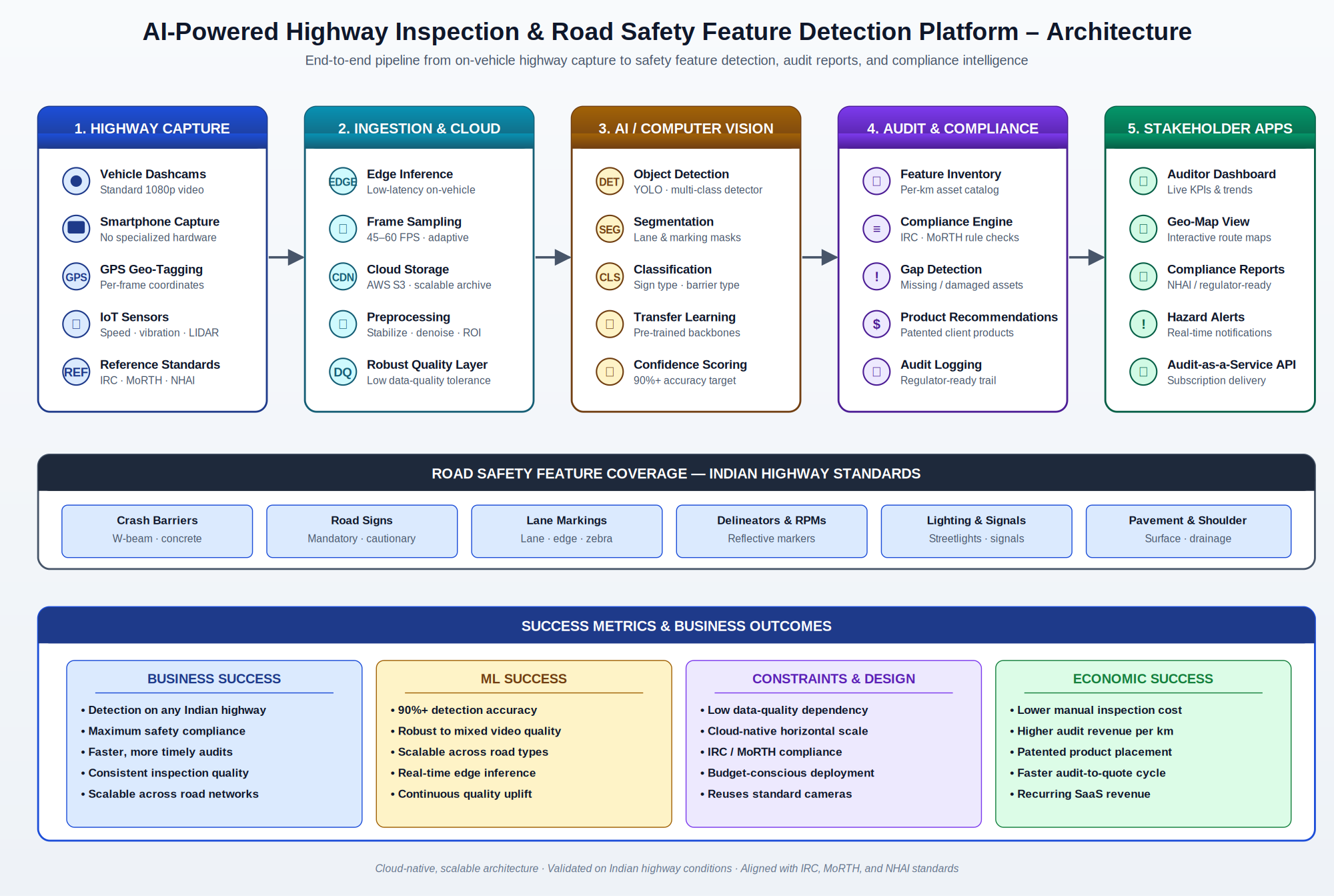
How does Drishti handle data quality, scale, and regulatory constraints?
Three constraints shaped the design — minimize data quality dependency, maximize scalability and performance, and ensure regulatory compliance.
Robust handling of mixed data quality
- Robust quality layer that handles mixed-resolution, mixed-lighting, and noisy footage
- Multi-frame fusion compensating for individual frame quality issues
- Confidence scoring tells auditors which detections to verify
- Augmentation-heavy training so models generalize across cameras and conditions
Scalability and performance
- Cloud-native architecture with horizontal scaling for multi-route inspections
- Edge inference on vehicles for real-time responsiveness and bandwidth efficiency
- Asynchronous, parallel processing pipelines for fleet-scale highway surveys
- API-first design supporting third-party fleet and surveyor integration
Regulatory and budget compliance
- Audit logic aligned with IRC, MoRTH, and NHAI standards
- Reuses standard cameras and consumer hardware — no specialized survey vehicles
- Phased, route-by-route rollout to align spend with proven ROI
- Open-source backbones to keep modeling and inference cost defensible
What measurable results does Drishti deliver?
Drishti was designed to move three things at once — highway safety compliance, manual inspection cost, and audit-driven revenue — in the same direction.
Highway safety and compliance
- Detects road safety features on any highway in India
- 85%+ pothole detection and 97%+ surface classification accuracy
- Faster, more timely detection of safety gaps and hazards
- Consistent, comparable audit outputs across regions and auditors
Cost and operational efficiency
- Reduced manual inspection cost across the surveyed network
- Lower labor effort per kilometre audited
- Faster audit-to-report turnaround with automated reports
- Scalable across additional road networks without linear headcount growth
Coverage and reach
- 8+ asset categories detected from a single video pass
- 45-60 FPS real-time inference on standard cameras
- GPS-tagged detections enable per-kilometre asset inventories
- Cloud-native deployment supports fleet-wide rollouts
Looking ahead — capability enhancement
- Extend to additional safety features and pavement-condition assessment
- Add predictive analytics for asset deterioration and replacement planning
- Layer in night-vision and adverse-weather robustness for round-the-clock audits
Looking ahead — scale and rollout
- Roll out across additional state, national, and expressway corridors
- Adapt to regional regulatory frameworks and concessionaire SLAs
- Enable cross-network benchmarking on safety KPIs
Looking ahead — long-term outcomes
- Drive sustained year-over-year growth in highway safety compliance
- Build a national-scale highway intelligence asset that compounds value
- Set a new, AI-assisted standard for road safety auditing in India
Drishti road safety AI — frequently asked questions
This section answers the questions most often asked about Drishti, AiSPRY's AI-powered road infrastructure intelligence platform. Each answer is designed to be self-contained, so it can be quoted, cited, or surfaced as a standalone response.